
What Makes Patricia the Most Powerful Hurricane Ever?
Part of the reason the storm intensified so quickly is an unusually deep pool of warm water off Mexico's coast.
Updated Saturday at 12:00 p.m. ET.
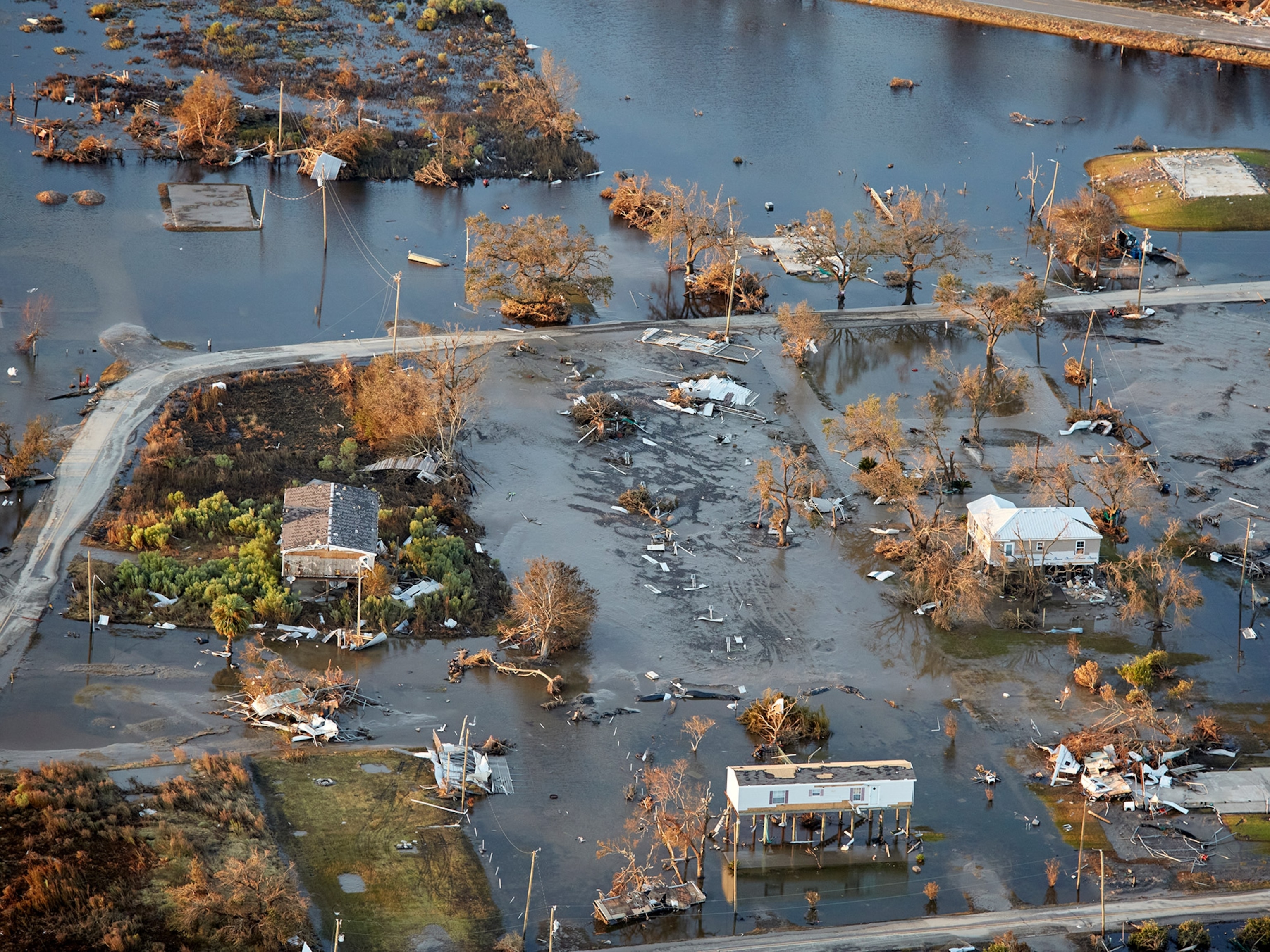
Hurricane Patricia, the most powerful hurricane ever recorded in the western hemisphere, hit the Pacific coast of Mexico Friday evening.
Patricia exploded from a tropical storm on Wednesday evening to a Category 5 hurricane on the Saffir-Simpson scale within 24 hours. Though it had been downgraded to a tropical depression by Saturday morning, Patricia's intensification was one of the most dramatic of any hurricane, cyclone, or typhoon on record.
"This is the type of worst case scenario that we fear," said Derrick Herndon, an atmospheric scientist at the Cooperative Institute for Meteorological Satellite Studies in Madison, Wisconsin, on Friday. He's never seen a storm grow so powerful so quickly.
Patricia packed sustained winds of 165 miles (265 kilometers) per hour when it hit southwestern Mexico at 6:15 p.m. local time. By early Saturday morning, its winds had weakened to about 75 (120 kilometers) miles per hour.
Mexican President Enrique Peña Nieto said late Friday that damage from the storm had been less than expected but that the picture of the toll was still emerging and that "we cannot let our guard down."
Scientists don't fully understand why Patricia grew so intense so quickly. But part of the reason is due to an unusually deep pool of warm water off Mexico's Pacific coast, says Kerry Emanuel, an atmospheric scientist at the Massachusetts Institute of Technology.

As a hurricane intensifies, it churns up the ocean beneath it, drawing deeper, colder water to the surface. Since tropical cyclones feed on warm water, that cooler water acts as a kind of brake, limiting how strong most hurricanes get, Emanuel says.
But in Patricia's case, the warm pool of water beneath the storm goes down nearly 200 feet (61 meters). "That makes it harder for the hurricane to churn up cold water," says Emanuel.
That deep blob of warm water could be due to this year's predicted strong El Niño, a weather pattern characterized by warmer-than-usual water in parts of the Pacific Ocean.

Given the limitations in understanding the mechanics of hurricanes and the effects of climate change on these storms, Herndon fears Patricia won't be the last nasty surprise we see.
Comparisons
Even though Patricia has already smashed records for hurricanes, it's not the most powerful storm to spin up. Super Typhoon Tip (hurricane, typhoon, and cyclone are different names for the same type of storm) grazed Japan in October 1979 and holds the record for the most powerful tropical cyclone on record based on minimum atmospheric pressure measurements.
The atmospheric pressure—measured in millibars—at the center of a hurricane is the preferred way to determine its power. "The lower the pressure, the stronger the winds," says Herndon.
The average, everyday atmospheric pressure is around 1,000 millibars. Tip was measured at 870 millibars. As of Friday afternoon, Patricia showed minimum values of 879 millibars.
Tip's wind speeds topped out at 190 miles (306 kilometers) per hour.
Super Typhoon Haiyan, which struck the Philippines in 2013, recorded pressures as low as 895 millibars with wind speeds of 195 miles (315 kilometers) per hour. Hurricane Katrina came in at 902 millibars with maximum wind speeds of 175 miles (282 kilometers) per hour.
The last comparable hurricane to form in the same area as Patricia was hurricane Linda in 1997. It reached Category 5 status with an atmospheric pressure of 902 millibars and wind speeds of 185 miles (295 kilometers) per hour.
This isn’t a perfect comparison, since atmospheric pressure at sea level is slightly lower in the western Pacific than in the eastern Pacific, Herndon says. To truly get a sense of a hurricane's power relative to other storms, scientists look at the difference between ambient pressures and the pressure in a tropical cyclone.
By that measure, Hurricane Patricia could be as powerful as Tip, Herndon says.
Follow Jane J. Lee on Twitter.
You May Also Like


Go Further
Animals
- Fireflies are nature’s light show at this West Virginia state parkFireflies are nature’s light show at this West Virginia state park
- These are the weird reasons octopuses change shape and colorThese are the weird reasons octopuses change shape and color
- Why young scientists want you to care about 'scary' speciesWhy young scientists want you to care about 'scary' species
- What rising temperatures in the Gulf of Maine mean for wildlifeWhat rising temperatures in the Gulf of Maine mean for wildlife
- He’s called ‘omacha,’ a dolphin that transforms into a man. Why?He’s called ‘omacha,’ a dolphin that transforms into a man. Why?
Environment
- What rising temperatures in the Gulf of Maine mean for wildlifeWhat rising temperatures in the Gulf of Maine mean for wildlife
- He’s called ‘omacha,’ a dolphin that transforms into a man. Why?He’s called ‘omacha,’ a dolphin that transforms into a man. Why?
- The northernmost flower living at the top of the worldThe northernmost flower living at the top of the world
- This beautiful floating flower is wreaking havoc on NigeriaThis beautiful floating flower is wreaking havoc on Nigeria
- What the Aral Sea might teach us about life after disasterWhat the Aral Sea might teach us about life after disaster
History & Culture
- Scientists find evidence of ancient waterway beside Egypt’s pyramidsScientists find evidence of ancient waterway beside Egypt’s pyramids
- This thriving society vanished into thin air. What happened?This thriving society vanished into thin air. What happened?
Science
- Why pickleball is so good for your body and your mindWhy pickleball is so good for your body and your mind
- Extreme heat can be deadly – here’s how to know if you’re at riskExtreme heat can be deadly – here’s how to know if you’re at risk
- Why dopamine drives you to do hard things—even without a rewardWhy dopamine drives you to do hard things—even without a reward
- What will astronauts use to drive across the Moon?What will astronauts use to drive across the Moon?
- Oral contraceptives may help lower the risk of sports injuriesOral contraceptives may help lower the risk of sports injuries
- How stressed are you? Answer these 10 questions to find out.
- Science
How stressed are you? Answer these 10 questions to find out.
Travel
- How to make perfect pierogi, Poland's famous dumplingsHow to make perfect pierogi, Poland's famous dumplings
- The best long-distance Alpine hike you've never heard ofThe best long-distance Alpine hike you've never heard of
- Fireflies are nature’s light show at this West Virginia state parkFireflies are nature’s light show at this West Virginia state park
- How to explore the highlights of Italy's dazzling Lake ComoHow to explore the highlights of Italy's dazzling Lake Como
- Going on a cruise? Here’s how to stay healthy onboardGoing on a cruise? Here’s how to stay healthy onboard
